

iVolve


Transform real-time mining and quarry machine data into valuable insights.
iVolve provides powerful Fleet Management Systems, designed for medium- to large-scale mining operations. These solutions facilitate real-time communication between your machines and the dispatch office, enabling you to effortlessly monitor production, maintenance data, and KPIs.
Check the history of past production cycles and replay incidents with iControl.
Get real-time equipment health data feeds with Mine 4D Maintenance.
Provide your operators with real-time feedback in-cab and monitor and record all parameters of the haul truckload cycle with Mine 4D Production.
Create, schedule, and run reports effortlessly with iReport.
Combine the benefits of real-time operational data and the precision of advanced machine control with Mine4D Guidance.
Proximiti™ integrates a long-range, high-speed GPS-based collision awareness system with a short-range, low-speed radar proximity detection system, providing enhanced situational awareness for operators.
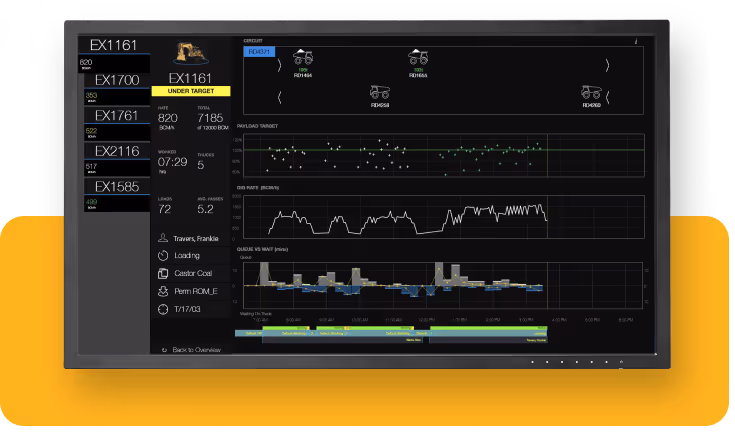
Production
iVolve Mine4D Production enables real-time decision-making in two ways: By providing real-time, in-cab operator feedback as well as by monitoring and recording the truckload cycle in real time. This way it offers a real-time snapshot across the entire site production fleet with user-friendly graphic visualisation tools that aid dispatch personnel and enable shift managers to make timely decisions.
Optimise truck loading
Optimise circuit operation
Improve labour efficiencies
Communicate with operators directly
Save time on data collection
Improve data collection accuracy
Early intervention of mistakes
Optimise vehicle utilisation
Easily locate vehicles and operators
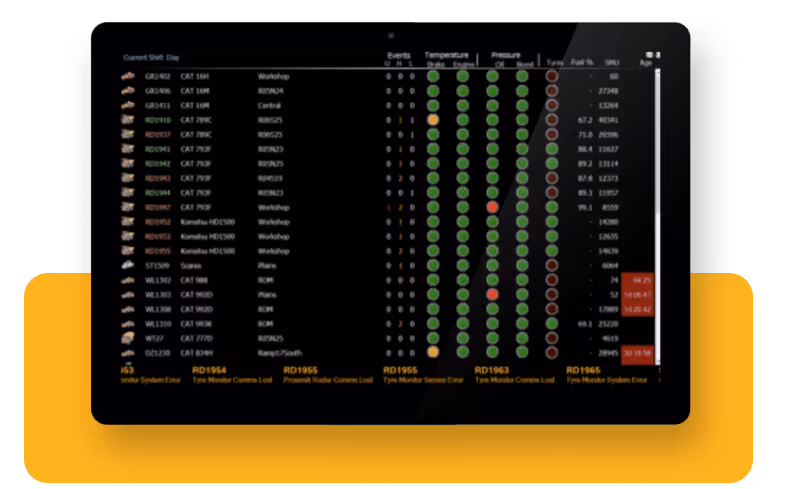
Maintenance and tyres
iVolve Mine4D Maintenance provides real-time equipment health data feeds. This data is displayed graphically via iReport dash¬boards at fleet and individual asset levels, with full data history available for informal and scheduled reporting. iVolve Mine4D Tyre™ provides mine site management, safety and maintenance teams with real-time access to tyre temperatures and pressures. Respond to over-temperature and under/over-pressure events before the tyre reaches critical status.
Early identify vehicle issues
Monitor and manage machine abuse
Monitor and manage overloads
Extend component life
Increase the availability of equipment
Minimise unscheduled downtimes
Identify equipment problems before failures arise
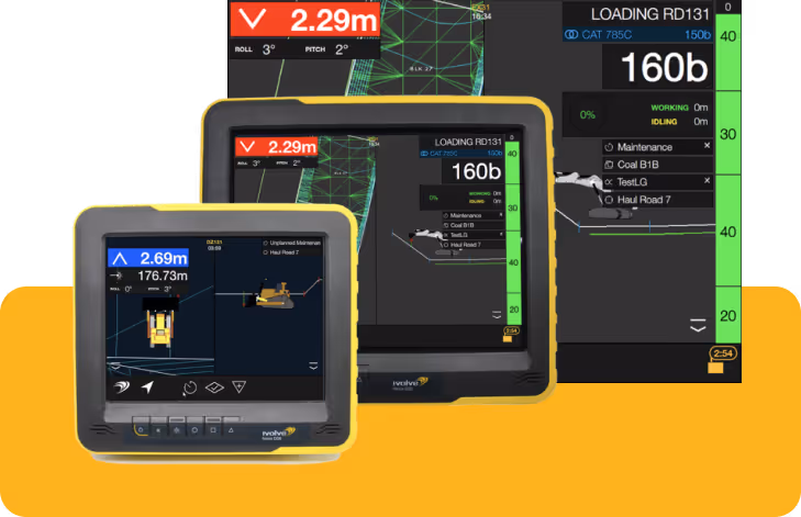
Guidance
iVolve Mine4D Guidance is an innovative approach to the use of technology in mining and quarries. Specifically designed to optimise operator activities, Guidance seamlessly integrates machine guidance and fleet management tasks. By combining real-time operational data with advanced machine guidance and control precision, Guidance offers numerous benefits to mining and quarry operations.
Compliance with design surface
Improve payload distribution
Improved dig location accuracy
Increase truck productivity
Improved material management
Move material once, reduce rework and rehandle
Better road design execution allows for maintained speeds
Reduce wear and tear of equipment
Operate vehicles safely with precise knowledge of component positioning and vehicle location.
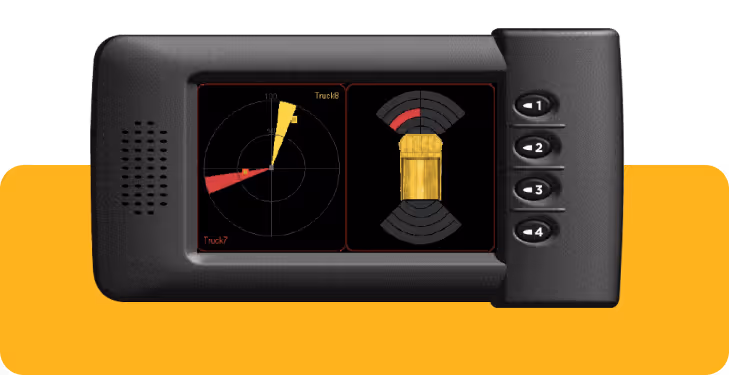
Proximiti™
Proximiti™ integrates a long-range, high-speed GPS based collision awareness system with a short-range, low-speed radar proximity detection system to provide enhanced situational awareness for operators of heavy, medium and light vehicles on mine sites.
Operators work efficiently with the confidence in knowledge of their surroundings
Easily report on incident investigation
Easily investigate incidents
Knowledge of small vehicles and personnel working beside large fleet
Alerts for keep out zones and speed limits
Surveyors and contractors alike use MAGNET Field to collect points, stake out road and site projects, lay out building components, and perform land surveys.
Ability to calculate, contour, and compare surfaces.
Surface staking with automatic Digital Terrain Model creation.
Colorised cut-and-fill indicator and volume calculations.
A secure cloud environment that connects your office and field teams improving your communication and collaboration. Use any web browser to view your data on a map, view redline models, and measure areas and distances.
View connected Topcon devices and transfer real-time data.
See a visual map of projects and geo-referenced datasets.
Seamlessly connect to Topcon’s MAGNET Field and Survey products.
Draft and design property plots, subdivision designs and land-development projects. Process data within an intuitive drafting environment and create simplified or detailed drawing layouts.
Full range of sub-division design tools.
Contour and surface creation, volumetrics and automated pad design.
User-defined title blocks, symbols and line types.
